
Esplanade, Kolkata: Difference between revisions
KylieTastic (talk | contribs) Reverted 3 edits by Chandan Guha (talk): Rvt broken map (TW) |
Soumava2002 (talk | contribs) No edit summary Tags: Mobile edit Mobile web edit |
||
| (40 intermediate revisions by 20 users not shown) | |||
| Line 1: | Line 1: | ||
{{Use Indian English|date=April 2017}} |
{{Use Indian English|date=April 2017}} |
||
{{Use dmy dates|date= |
{{Use dmy dates|date=July 2022}} |
||
{{Infobox settlement |
{{Infobox settlement |
||
<!--See Template:Infobox Settlement for additional fields that may be available--> |
<!--See Template:Infobox Settlement for additional fields that may be available--> |
||
| Line 10: | Line 10: | ||
|native_name = <!-- if different from the English name --> |
|native_name = <!-- if different from the English name --> |
||
|nickname = |
|nickname = |
||
|settlement_type =Neighbourhood in Kolkata (Calcutta) <!-- e.g. Town, Village, City, etc.--> |
|settlement_type = Neighbourhood in Kolkata (Calcutta) <!-- e.g. Town, Village, City, etc.--> |
||
|total_type = <!-- to set a non-standard label for total area and population rows --> |
|total_type = <!-- to set a non-standard label for total area and population rows --> |
||
|motto = |
|motto = |
||
| Line 16: | Line 16: | ||
|image_skyline = Esplanade Row East.jpg |
|image_skyline = Esplanade Row East.jpg |
||
|imagesize = |
|imagesize = |
||
|image_caption = Esplanade Row (East) (now Sidhu Kanu Dahar) |
|image_caption = Esplanade Row (East) (now Sidhu Kanu Dahar) |
||
|image_flag = |
|image_flag = |
||
|flag_size = |
|flag_size = |
||
| Line 41: | Line 41: | ||
|pushpin_mapsize = |
|pushpin_mapsize = |
||
<!-- Location ------------------> |
<!-- Location ------------------> |
||
|subdivision_type1 |
|subdivision_type1 = Country |
||
|subdivision_name1 |
|subdivision_name1 = {{IND}} |
||
|subdivision_type2 = [[States and territories of India|State]] |
|subdivision_type2 = [[States and territories of India|State]] |
||
|subdivision_name2 = [[West Bengal]] |
|subdivision_name2 = [[West Bengal]] |
||
| Line 116: | Line 116: | ||
}} |
}} |
||
'''Esplanade''' |
'''Esplanade''' is a neighbourhood of [[Kolkata|Central Kolkata]], located at the heart of city with being the city's [[Central business district]]. This is a conventional [[esplanade]] because the Ganga river ([[Ganges]]), also known as [[Hooghly river]], flows nearby and it is adjacent to the large fields of [[Maidan (Kolkata)|Maidan]] extending up to [[Fort William, India|Fort William]]. |
||
==History== |
==History== |
||
The Esplanade was the name given to the northern portion of jungle, which later formed the [[Maidan (Kolkata)|Maidan]]. In olden days, it stretched from [[Dharmatala |
The Esplanade was the name given to the northern portion of jungle, which later formed the [[Maidan (Kolkata)|Maidan]]. In olden days, it stretched from [[Dharmatala]] (now Lenin Sarani) to Chandpal Ghat on the [[Hooghly river]]. In the days of [[Warren Hastings]], it formed a favourite promenade for 'elegant walking parties'. |
||
The first pictures of the area is at the end of eighteenth century by Daniell and [[William Baillie (artist)|William Baillie]]. The old Government House and the Council House were conspicuous objects in each drawing. He also presented an addition view in the shape of two elephants with a crowd of attendants.<ref name="Cotton">Cotton, H.E.A., ''Calcutta Old and New'', 1909/1980, |
The first pictures of the area is at the end of eighteenth century by Daniell and [[William Baillie (artist)|William Baillie]]. The old Government House and the Council House were conspicuous objects in each drawing. He also presented an addition view in the shape of two elephants with a crowd of attendants.<ref name="Cotton">Cotton, H.E.A., ''Calcutta Old and New'', 1909/1980, pp. 254–261, General Printers and Publishers Pvt. Ltd. {{PD-notice}}</ref> |
||
| ⚫ | The strengthening of British power, subsequent to their victory in the [[Battle of Plassey]] was followed by the construction of the new [[Fort William, India|Fort William]], in 1758. The European inhabitants of [[Kalikata]] gradually forsook the narrow limits of the old palisades and moved to around the [[Maidan (Kolkata)|Maidan]].<ref>Cotton, H.E.A., p. 72.</ref> |
||
[[Bourne & Shepherd]], photographic studio was established here in 1867 by British photographers, [[Samuel Bourne]] and [[Charles Shepherd (photographer)|Charles Shepherd]]. |
|||
| ⚫ | The first recorded football match in Kolkata was played on the Esplanade in the second week of April 1858 between the Calcutta Club of Civilians and the 'Gentlemen of Barrakpur'. There had been matches earlier but those were not documented.<ref>Nandy, Moti, ''Calcutta Soccer'', p. 316, in ''Calcutta, the Living City'', Vol II, edited by Sukanta Chaudhuri, 1990/2005, p. 2, Oxford University Press, {{ISBN|0-19-563697-X}}.</ref> |
||
| ⚫ | The strengthening of British power, subsequent to their victory in the [[Battle of Plassey]] was followed by the construction of the new [[Fort William, India|Fort William]], in 1758. The European inhabitants of [[Kalikata]] gradually forsook the narrow limits of the old palisades and moved to around the Maidan .<ref>Cotton, H.E.A., p. 72.</ref> |
||
| ⚫ | The first recorded |
||
==The locality== |
==The locality== |
||
| Line 133: | Line 131: | ||
===Esplanade Row=== |
===Esplanade Row=== |
||
The street named Esplanade Row, finds a mention in the map of 1784, running from Dhurmotollah right on to the banks of the river at Chandpal Ghat, passing on its way [[Raj Bhavan, Kolkata|Government House]] and Council House, both facing south. Subsequently, it was divided by the gardens of Government House into two parts, Esplanade Row (East) and Esplanade Row (West).<ref name = "Cotton"/> Esplanade Row (West) now runs between Government Place (West) and Strand Road, through the High Court. Esplanade Row (East) has been renamed Sidhu Kanu Dahar and occupies the northern end of the Maidan.<ref>Map nos. 28, 29, Detail Maps of 141 Wards of Kolkata, D.R.Publication and Sales Concern, 66 College Street, Kolkata – 700073</ref> |
The street named Esplanade Row, finds a mention in the map of 1784, running from Dhurmotollah right on to the banks of the river at Chandpal Ghat, passing on its way [[Raj Bhavan, Kolkata|Government House]] and Council House, both facing south. Subsequently, it was divided by the gardens of Government House into two parts, Esplanade Row (East) and Esplanade Row (West).<ref name = "Cotton"/> Esplanade Row (West) now runs between Government Place (West) and [[Strand Road, Kolkata|Strand Road]], through the [[Kolkata High Court]]. Esplanade Row (East) has been renamed Sidhu Kanu Dahar and occupies the northern end of the Maidan.<ref>Map nos. 28, 29, Detail Maps of 141 Wards of Kolkata, D.R.Publication and Sales Concern, 66 College Street, Kolkata – 700073</ref> |
||
[[File:Kolkata Esplanade.jpg|thumb|250px|right|Esplanade Row (East) in the 19th century – a painting by Allom, T.]] |
[[File:Kolkata Esplanade.jpg|thumb|250px|right|Esplanade Row (East) in the 19th century – a painting by Allom, T.]] |
||
As a result of the movement of Europeans from the old palisades in the eighteenth century, Esplanade Row took on a new look. The most important public buildings and imposing private houses lined the northern side of the Esplanade, facing the Maidan on the south. |
As a result of the movement of Europeans from the old palisades in the eighteenth century, Esplanade Row took on a new look. The most important public buildings and imposing private houses lined the northern side of the Esplanade, facing the Maidan on the south. "Esplanade Row", wrote Mrs. Fay, "seems to be composed of palaces".<ref name = "Lahiri">Lahiri Choudhury, Dhriti Kanta, ''Trends in Calcutta Architecture'', in ''Calcutta, the Living City'', Vol I, pp. 156–160, edited by Sukanta Chaudhuri, Oxford University Press, {{ISBN|0-19-563696-1}}.</ref> |
||
The [[Tipu Sultan Mosque]] is at the junction of Esplanade Row (East) and Dhurmotollah Street.A number of statues adorn the area. |
The [[Tipu Sultan Mosque]] is at the junction of Esplanade Row (East) and Dhurmotollah Street (Lenin Sarani). A number of statues adorn the area. |
||
===Old Court House Street=== |
===Old Court House Street=== |
||
| ⚫ | Old Court House Street connects Esplanade Row (East) (or presently Sidhu Kanu Dahar) with [[B.B.D. Bagh]], earlier known as Dalhousie Square. It acquired its name from the Old Court house, that was located where St. Andrew's Church now stands. It served originally as the Supreme Court, until it was demolished in 1792. The northern part of the stretch is known as B.B.D. Bagh (East). It was constructed around 1781, when the finishing touches were put to the new Fort William. It is linked with the name of Col. Henry Watson, who brought about many improvements in Calcutta, including the laying out of surrounding Esplanade. The Red Road is an extension of this street.<ref name = "Cotton"/> The stretch of Old Court House Street from the crossing with Ganesh Avenue or the south-eastern corner of B.B.D. Bagh to the crossing with Waterloo Street has been renamed Hemanta Basu Sarani. The stretch from the crossing with Waterloo Street to the crossing with Rani Rashmoni Avenue has been renamed Marx Engels Beethi Road.<ref>Map no. 29, Detail Maps of 141 Wards of Kolkata.</ref> |
||
| ⚫ | Old Court House Street connects Esplanade Row (East) (or presently Sidhu Kanu Dahar) with [[B. |
||
===Council House Street=== |
===Council House Street=== |
||
Council House Street connects the western part of B.B.D.Bagh with Esplanade Row. It acquires its name from the old council house, which stood on the western portion of Government House. It was pulled down in 1800. The southern part of the street was subsequently called Government Place West.<ref name = "Cotton"/>[[Fort William College]] was located at the corner of Council House Street.<ref>Cotton, H.E.A., p. 271.</ref> |
Council House Street connects the western part of B.B.D. Bagh with Esplanade Row. It acquires its name from the old council house, which stood on the western portion of Government House. It was pulled down in 1800. The southern part of the street was subsequently called Government Place West.<ref name = "Cotton"/> [[Fort William College]] was located at the corner of Council House Street.<ref>Cotton, H.E.A., p. 271.</ref> |
||
==Traffic hub== |
==Traffic hub== |
||
Esplanade has always been a major traffic hub. In 1902, the first electric tram car (route no. 36) ran from Esplanade to [[Kidderpore]]. In 1984, the first underground metro railway ([[Kolkata Metro Line 1]]) in India, started from [[Tollygunge]] to Esplanade and in a similar way East-West metro ([[Kolkata Metro Line 2]]) was opened on a truncated section from Esplanade to [[Howrah Maidan metro station|Howrah Maidan]].<ref>{{cite web| url =http://www.calcuttaweb.com/history.shtml| title =Kolkata (Calcutta) History| access-date =2007-07-25| publisher =calcuttaweb.com| url-status =dead| archive-url =https://web.archive.org/web/20070510193408/http://www.calcuttaweb.com/history.shtml| archive-date =10 May 2007}}</ref> Today, Esplanade is the busiest bus terminus and largest Metro interchange of [[West Bengal]]. [[Trams in Kolkata|Kolkata trams]] route no. 5, 25 and 36 also start their journey from Esplanade. |
|||
In 2002, it was estimated that during rush hours some 200,000 to 300,000 vehicles passed through |
In 2002, it was estimated that during rush hours some 200,000 to 300,000 vehicles passed through Esplanade.<ref>{{cite web |
||
|url=http://www.thestatesman.net/page.arcview.php?clid=6&id=29113&usrsess=1 |
|||
|title=Better Kolkata Campaign. |
|||
|access-date=2007-07-25 |
|||
|publisher=The Statesman, 17 June 2002 |
|||
|archive-url=https://web.archive.org/web/20070929103131/http://www.thestatesman.net/page.arcview.php?clid=6&id=29113&usrsess=1 |
|||
|archive-date=29 September 2007 |
|||
|url-status=dead |
|||
}}</ref> |
|||
|df=dmy |
|||
}}</ref> In the Esplanade area, the noise levels are 75–84 dB.<ref>Chakraborti, Dipankar, ''Calcutta's Environment'', p.185, in ''Calcutta, the Living City'', Vol II</ref> |
|||
According to transport department officials, over 2,000 long-distance buses operate from the city. Most of the state and private buses originate from the Esplanade and [[Babughat]], nearby |
According to transport department officials, over 2,000 long-distance buses operate from the city. Most of the state and private buses originate from the Esplanade and [[Babughat]], nearby.<ref>{{cite news | url = http://www.telegraphindia.com/1030818/asp/calcutta/story_2272211.asp |
||
| archive-url = https://archive.today/20130204101000/http://www.telegraphindia.com/1030818/asp/calcutta/story_2272211.asp |
|||
| ⚫ | |||
| url-status = dead |
|||
| archive-date = 4 February 2013 |
|||
| ⚫ | |||
}}</ref><ref>{{cite news |
}}</ref><ref>{{cite news |
||
|url = http://timesofindia.indiatimes.com/calcutta-times/breather-for-choking-esplanade/articleshow/35302852.cms | title = Breather for choking esplanade? | |
|url = http://timesofindia.indiatimes.com/calcutta-times/breather-for-choking-esplanade/articleshow/35302852.cms | title = Breather for choking esplanade? | access-date = 2007-07-25 | last = Konar | first = Debashis | publisher = Times of India, 24 January 2003 | date=24 January 2003}}</ref> |
||
[[Kolkata Metro Line 3]], which are under construction, will pass through Esplanade soon. |
|||
[[Eden Gardens railway station]] on [[Kolkata Circular Railway]] line is the nearest railway station. [[Sealdah Station]], one of the five major railway-terminals of [[Kolkata Metropolitan Area]], is also located nearby. |
|||
==Rallies== |
==Rallies== |
||
| Line 173: | Line 174: | ||
== Gallery == |
== Gallery == |
||
<gallery mode="packed"> |
<gallery mode="packed"> |
||
File:Esplanade-Mansion-side-view-Kolkata.jpg|[[Esplanade Mansions, Kolkata|Esplanade Mansions]] |
|||
| ⚫ | |||
File:Esplanade Bus Station.jpg|Esplanade |
File:Esplanade Bus Station.jpg|Esplanade Bus Station with [[Shaheed Minar, Kolkata|Shaheed Minar]] in the background |
||
File:Songrokkhon.JPG|Tram Museum (Smaranika) in Esplanade Tram Terminus |
|||
File:Kolkata Military Secretariat.jpg|[[Ordnance Factory Board]]'s |
File:Kolkata Military Secretariat.jpg|[[Ordnance Factory Board]]'s Office<ref>{{cite web |url=http://dgaeroqa.gov.in/rd-kolkata.htm |title = Office of the Regional Director, AQA, DGAQA, KOLKATA}}</ref> |
||
File:Victoria House - Esplanade - Kolkata 2011-09-11 00541.jpg|Victoria House |
File:Victoria House - Esplanade - Kolkata 2011-09-11 00541.jpg|Victoria House |
||
File:Metropolitan Building - Esplanade - Kolkata 2012-09-19 0013.jpg|[[Metropolitan Building (Kolkata)|Metropolitan Building]] |
|||
File:Metro Cinema - Esplanade - Kolkata 2011-12-18 0024.JPG|[[Metro Cinema (Kolkata)|Metro Cinema]] |
File:Metro Cinema - Esplanade - Kolkata 2011-12-18 0024.JPG|[[Metro Cinema (Kolkata)|Metro Cinema]] |
||
| ⚫ | |||
</gallery> |
</gallery> |
||
| Line 184: | Line 188: | ||
==References== |
==References== |
||
{{reflist |
{{reflist}} |
||
==External links== |
==External links== |
||
Latest revision as of 17:47, 11 July 2024
Esplanade | |
|---|---|
Neighbourhood in Kolkata (Calcutta) | |
 Esplanade Row (East) (now Sidhu Kanu Dahar) | |
 | |
| Coordinates: 22°33′54″N 88°20′47″E / 22.564955°N 88.346346°E | |
| Country | |
| State | West Bengal |
| City | Kolkata |
| District | Kolkata |
| Metro Station | Esplanade and Chandni Chowk |
| Municipal Corporation | Kolkata Municipal Corporation |
| KMC wards | 45, 46 |
| Elevation | 36 ft (11 m) |
| Population | |
| • Total | For population see linked KMC ward pages |
| Time zone | UTC+5:30 (IST) |
| PIN | 700069 |
| Area code | +91 33 |
| Lok Sabha constituency | Kolkata Uttar |
| Vidhan Sabha constituency | Chowranghee |
Esplanade is a neighbourhood of Central Kolkata, located at the heart of city with being the city's Central business district. This is a conventional esplanade because the Ganga river (Ganges), also known as Hooghly river, flows nearby and it is adjacent to the large fields of Maidan extending up to Fort William.
History
[edit]The Esplanade was the name given to the northern portion of jungle, which later formed the Maidan. In olden days, it stretched from Dharmatala (now Lenin Sarani) to Chandpal Ghat on the Hooghly river. In the days of Warren Hastings, it formed a favourite promenade for 'elegant walking parties'.
The first pictures of the area is at the end of eighteenth century by Daniell and William Baillie. The old Government House and the Council House were conspicuous objects in each drawing. He also presented an addition view in the shape of two elephants with a crowd of attendants.[1]
The strengthening of British power, subsequent to their victory in the Battle of Plassey was followed by the construction of the new Fort William, in 1758. The European inhabitants of Kalikata gradually forsook the narrow limits of the old palisades and moved to around the Maidan.[2]
The first recorded football match in Kolkata was played on the Esplanade in the second week of April 1858 between the Calcutta Club of Civilians and the 'Gentlemen of Barrakpur'. There had been matches earlier but those were not documented.[3]
The locality
[edit]A number of roads and streets form part of or have been linked integrally with the Esplanade for many years.
Esplanade Row
[edit]The street named Esplanade Row, finds a mention in the map of 1784, running from Dhurmotollah right on to the banks of the river at Chandpal Ghat, passing on its way Government House and Council House, both facing south. Subsequently, it was divided by the gardens of Government House into two parts, Esplanade Row (East) and Esplanade Row (West).[1] Esplanade Row (West) now runs between Government Place (West) and Strand Road, through the Kolkata High Court. Esplanade Row (East) has been renamed Sidhu Kanu Dahar and occupies the northern end of the Maidan.[4]

As a result of the movement of Europeans from the old palisades in the eighteenth century, Esplanade Row took on a new look. The most important public buildings and imposing private houses lined the northern side of the Esplanade, facing the Maidan on the south. "Esplanade Row", wrote Mrs. Fay, "seems to be composed of palaces".[5]
The Tipu Sultan Mosque is at the junction of Esplanade Row (East) and Dhurmotollah Street (Lenin Sarani). A number of statues adorn the area.
Old Court House Street
[edit]Old Court House Street connects Esplanade Row (East) (or presently Sidhu Kanu Dahar) with B.B.D. Bagh, earlier known as Dalhousie Square. It acquired its name from the Old Court house, that was located where St. Andrew's Church now stands. It served originally as the Supreme Court, until it was demolished in 1792. The northern part of the stretch is known as B.B.D. Bagh (East). It was constructed around 1781, when the finishing touches were put to the new Fort William. It is linked with the name of Col. Henry Watson, who brought about many improvements in Calcutta, including the laying out of surrounding Esplanade. The Red Road is an extension of this street.[1] The stretch of Old Court House Street from the crossing with Ganesh Avenue or the south-eastern corner of B.B.D. Bagh to the crossing with Waterloo Street has been renamed Hemanta Basu Sarani. The stretch from the crossing with Waterloo Street to the crossing with Rani Rashmoni Avenue has been renamed Marx Engels Beethi Road.[6]
Council House Street
[edit]Council House Street connects the western part of B.B.D. Bagh with Esplanade Row. It acquires its name from the old council house, which stood on the western portion of Government House. It was pulled down in 1800. The southern part of the street was subsequently called Government Place West.[1] Fort William College was located at the corner of Council House Street.[7]
Traffic hub
[edit]Esplanade has always been a major traffic hub. In 1902, the first electric tram car (route no. 36) ran from Esplanade to Kidderpore. In 1984, the first underground metro railway (Kolkata Metro Line 1) in India, started from Tollygunge to Esplanade and in a similar way East-West metro (Kolkata Metro Line 2) was opened on a truncated section from Esplanade to Howrah Maidan.[8] Today, Esplanade is the busiest bus terminus and largest Metro interchange of West Bengal. Kolkata trams route no. 5, 25 and 36 also start their journey from Esplanade.
In 2002, it was estimated that during rush hours some 200,000 to 300,000 vehicles passed through Esplanade.[9]
According to transport department officials, over 2,000 long-distance buses operate from the city. Most of the state and private buses originate from the Esplanade and Babughat, nearby.[10][11]
Kolkata Metro Line 3, which are under construction, will pass through Esplanade soon.
Eden Gardens railway station on Kolkata Circular Railway line is the nearest railway station. Sealdah Station, one of the five major railway-terminals of Kolkata Metropolitan Area, is also located nearby.
Rallies
[edit]The growing influence of the left-wing, particularly the Communist Party of India in organising urban protest was strongly felt from around 1957. The old institutions of mass mobilisation were strengthened to suit the agitation-oriented strategy of various political parties. A particularly significant expression of this agitation-oriented form of opposition to government policies was the way in which massive demonstrations of tens of thousands of people were organised in the heart of the city. Esplanade East, and Brigade Parade ground, lying just outside the citadels of power, were the new rallying points of mass protest.[12]
Gallery
[edit]-

-
 Esplanade Bus Station with Shaheed Minar in the background
 -
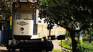 Tram Museum (Smaranika) in Esplanade Tram Terminus
 -
![Ordnance Factory Board's Office[13]](//upload.wikimedia.org/wikipedia/commons/thumb/8/8e/Kolkata_Military_Secretariat.jpg/240px-Kolkata_Military_Secretariat.jpg) Ordnance Factory Board's Office[13]
Ordnance Factory Board's Office[13] -
 Victoria House
 -

-

-


![Ordnance Factory Board's Office[13]](/https/en.wikipedia.org/wiki/File:Kolkata_Military_Secretariat.jpg)


See also
[edit]References
[edit]- ^ a b c d Cotton, H.E.A., Calcutta Old and New, 1909/1980, pp. 254–261, General Printers and Publishers Pvt. Ltd.
 This article incorporates text from this source, which is in the public domain.
- ^ Cotton, H.E.A., p. 72.
- ^ Nandy, Moti, Calcutta Soccer, p. 316, in Calcutta, the Living City, Vol II, edited by Sukanta Chaudhuri, 1990/2005, p. 2, Oxford University Press, ISBN 0-19-563697-X.
- ^ Map nos. 28, 29, Detail Maps of 141 Wards of Kolkata, D.R.Publication and Sales Concern, 66 College Street, Kolkata – 700073
- ^ Lahiri Choudhury, Dhriti Kanta, Trends in Calcutta Architecture, in Calcutta, the Living City, Vol I, pp. 156–160, edited by Sukanta Chaudhuri, Oxford University Press, ISBN 0-19-563696-1.
- ^ Map no. 29, Detail Maps of 141 Wards of Kolkata.
- ^ Cotton, H.E.A., p. 271.
- ^ "Kolkata (Calcutta) History". calcuttaweb.com. Archived from the original on 10 May 2007. Retrieved 25 July 2007.
- ^ "Better Kolkata Campaign". The Statesman, 17 June 2002. Archived from the original on 29 September 2007. Retrieved 25 July 2007.
- ^ Mukherjee, Shankar (18 August 2003). "Bypass, Setu sites for twin central bus terminals". Calcutta, India: The Telegraph, 18 August 2003. Archived from the original on 4 February 2013. Retrieved 25 July 2007.
- ^ Konar, Debashis (24 January 2003). "Breather for choking esplanade?". Times of India, 24 January 2003. Retrieved 25 July 2007.
- ^ Chaterjee, Partha, The Political Culture of Calcutta, p. 30, in Calcutta, the Living City, Vol II
- ^ "Office of the Regional Director, AQA, DGAQA, KOLKATA".
External links
[edit] Kolkata/Esplanade travel guide from Wikivoyage