
Jõelähtme Parish
Jõelähtme Parish
Jõelähtme vald | |
|---|---|
 Jägala waterfall | |
 Flag  Coat of arms | |
 Jõelähtme Parish within Harju County. | |
| Country | |
| County | |
| Administrative centre | Jõelähtme |
| Government | |
| • Mayor | Andrus Umboja |
| Area | |
| • Total | 210.86 km2 (81.41 sq mi) |
| Population (2022) | |
| • Total | 6,969[1] |
| ISO 3166 code | EE-245 |
| Website | www.joelahtme.ee |
Jõelähtme Parish (Estonian: Jõelähtme vald) is a rural municipality in Harju County, north-western Estonia. It has a population of 6,969 and an area of 210.86 km2 (81.41 sq mi), the population density is 25.3770/km2 (65.726/sq mi)[2]
The administrative centre of Jõelähtme Parish is Jõelähtme village. It is located 20 km east from the centre of Estonia's capital, Tallinn.
History
Established in 1816.
During World War II, 6,000 Jews and Roma were murdered by Estonian Nazi collaborators under German supervision. Mass executions were carried out on sand dunes called Kalevi-Liiva where a memorial has been erected.
Local government
Current mayor (vallavanem) is Andrus Umboja[3] and chairman of the council (volikogu esimees) is Art Kuum.[4]
Religion
Religion in Jõelähtme Parish (2021) [1]
Geography
Settlements
There are 2 small boroughs (est: alevikud, sg. - alevik) and 34 villages (est: külad, sg. - küla) in Jõelähtme Parish.
Small boroughs: Kostivere, Loo.
Villages: Aruaru, Haapse, Haljava, Ihasalu, Iru, Jägala, Jägala-Joa, Jõelähtme, Jõesuu, Kaberneeme, Kallavere, Koila, Koipsi, Koogi, Kostiranna, Kullamäe, Liivamäe, Loo, Maardu, Manniva, Neeme, Nehatu, Parasmäe, Rammu, Rebala, Rohusi, Ruu, Saha, Sambu, Saviranna, Ülgase, Uusküla, Vandjala, Võerdla.
Landmarks
- Jägala Waterfall
- Rebala Heritage Reserve
- Kostivere karst area
- Jõelähtme church
- Kaberneeme beach
- Kalevi-Liiva memorial
- Ülgase caves
Gallery
-
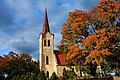
 Saha chapel
 -
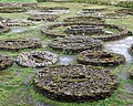 Bronze Age stone cist graves
 -

-
-
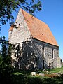
 Jõelähtme church
 -
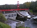 Linnamäe hydroelectric power plant
 -

-
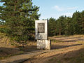 Memorial at Kalevi-Liiva
 -
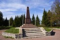 Monument to the Estonian War of Independence
 -
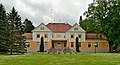 Maardu manor house
 -
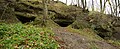 Ülgase caves
 -
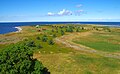 Rammu Island
 -
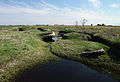
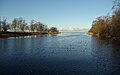 Mouth of the Jägala river


_Summer_2014_(1).JPG)


References
- ^ "Elanike arv - Eesti Linnade ja Valdade Liit".
- ^ "Population figure and composition". Statistics Estonia. Retrieved 9 June 2012.
- ^ "Vallavalitsus" (in Estonian). Jõelähtme Vallavalitsus. Retrieved 11 December 2009.
- ^ "Vallavolikogu koosseis" (in Estonian). Jõelähtme Vallavalitsus. Retrieved 11 December 2009.
External links
- Official website (in Estonian)
- Map of Jõelähtme Parish
- Non-official public forum (in Estonian)