
Logan, Victoria
| Logan Victoria | |
|---|---|
 The Logan Pub | |
 Logan | |
| Coordinates | 36°37′17.6″S 143°29′27.8″E / 36.621556°S 143.491056°E |
| Population | 59 (SAL 2021)[1] |
| Postcode(s) | 3475 |
| LGA(s) | Shire of Loddon |
| State electorate(s) | Ripon |
| Federal division(s) | Mallee |
Logan is a locality in Victoria, Australia. It is located at the intersection of Bendigo-St Arnaud Road (Wimmera Highway) and Logan-Wedderburn Road in the Loddon Shire.
The Logan Pub (or Avoca Forest Hotel) has accommodation and hosts events.
History
Logan was once a larger town during the Victorian Gold Rush. There was a post office, school, two churches, a community hall, a general store and other buildings. Logan Post Office opened on 18 January 1886 and closed in 1974.[2] The locality had a medium-sized oval which was home ground for a local Australian Rules football team.
There have been three pubs in the Logan's history - the first two have been demolished.
Gallery
-
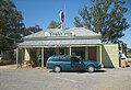 The Logan Pub
 -
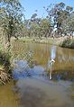 The Avoca River, near Logan
 -
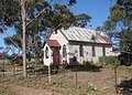 The old church


References
- ^ Australian Bureau of Statistics (28 June 2022). "Logan (suburb and locality)". Australian Census 2021 QuickStats. Retrieved 28 June 2022.
- ^ Phoenix Auctions History, Post Office List, retrieved 6 April 2021
External links
This article about a location in the Mallee is a stub. You can help Wikipedia by expanding it. |